3.65 lakh sq mt proposed to be dropped, 22.96 lakh sq mt added to command area
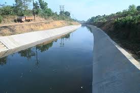
The government has proposed a reshuffle of areas falling under the command of the Tillari Irrigation Project.
MAPUSA
In a move that signals a recalibration of irrigation priorities amid changing land-use patterns in coastal and hinterland Goa, the State government has proposed a reshuffle of areas falling under the command of the Tillari Irrigation Project, deleting some pockets while bringing new tracts under its fold.
The decision appears aimed at aligning irrigation coverage with present agricultural realities.
According to a notification published in the Official Gazette, 3.65 lakh square metres (36.53 hectares) of land has been proposed to be deleted from the project’s command area.
These lands are located in Dhargal and Torsem in Pernem taluka; Calangute, Assagao, Anjuna, Parra and Revora in Bardez taluka and Latambarcem, Sarvan, Bicholim and Mayem in Bicholim taluka.
At the same time, around 22.96 lakh square metres (292.96 hectares) in Payem, Pernem, Corgao and Paliem villages of Pernem and Bicholim talukas has been proposed to be notified as command area under the project.
The Command Area Development Board partially modified its earlier notification dated November 25, 2024, after receiving representations from affected landowners seeking exclusion of certain survey holdings.
At its meeting held on January 7, 2026, the Board approved the omission of these areas, subject to applicants paying compensation at the government-approved rate of Rs. 105.70 per square metre within 30 days from publication of the notification.
The notification invites objections and suggestions, if any, within 30 days to the Member Secretary of the Command Area Development Board at the Office of the Superintending Engineer, Circle-II, Water Resources Department, Karaswada.
The Board stated that the inclusion of the additional 22.96 lakh square metres is intended to ensure “more effective and comprehensive utilisation of irrigation potential” under the project.
Though the notification does not elaborate on the detailed reasoning, officials suggest the move is part of a rationalisation exercise.
A senior engineer associated with the project, speaking on condition of anonymity, said that certain deleted areas – particularly in parts of Bardez – have witnessed rapid urbanisation and a shift away from agriculture.
“In some stretches, either the irrigation network was not technically viable due to topography or the agricultural demand had declined substantially. The newly proposed areas, on the other hand, are largely cultivable and better aligned with the existing canal distribution system,” the engineer said.
Analysts point out that large irrigation projects often undergo such mid-course corrections to improve utilisation of created potential, especially when audit observations flag gaps between infrastructure created and actual irrigated area.