


MARGAO
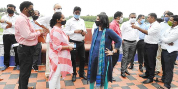
The National Green Tribunal-constituted joint Committee comprising of Goa Sate Environment Impact Assessment Agency (SEIAA) finally descended on the banks of the Tolleaband Lake on Friday to gather first-hand information of ground reality from villagers of Benaulim and Seraulim who have been demanding construction of the remaining part of the 2.75-km long western bypass on stilts.
When the team descended on the site of the lake, the adjoining river Sal at the Kharebandh bridge was not flowing in full spate and neither was the Tolleaband lake inundated with flood water since it has not rained heavily in the last few days. Members of the inspection team came across lush green carpet of vegetation at the sprawling lake. Fortunately, Director, Goa Coastal Zone Management Authority (GCZMA) Dashrath Redkar recalled how he (as the deputy Collector, Margao around 2011) had got the migrants inhabiting the Tolleaband evacuated to Jawaharlal Nehru stadium after being marooned by the flood waters.
NGT-constituted team’s attention was also drawn to the plan prepared around two decades ago by former deputy Collector, Margao Sanjit Rodrigues, presently posted in the South Collectorate as Additional Collector, suggesting a re-think on the western bypass alignment passing through the wetlands.
Environment Secretary Kunal, GCZMA Director Dashrath Redkar, Goa State Pollution Control Board Environment engineer Sanjeev Joglekar, South district Collector, Ruchika Katyal, WRD Executive engineer, Ankush Gaonkar, besides other team members including Salcete Mamlatdar Prataprao Gaonkar, discussed amongst themselves the bypass alignment passing through the flood plains of river Sal.
Petitioner in the NGT, Royla Fernande was heard making a fervent plea to the team to build the bypass on stilts and save the hydrology and the rich biodiversity of Benaulim and Seraulim. Royla explained to Collector Ruchika that it’s not just the Tolleaband lake that is facing the danger from the bypass on earthen embankments which is expected to cut through the lake, but also large tracts of agricultural fields of Benaulim and Seraulim, right up to Nuvem that will be affected by the flood waters.
The team later headed to the northern side of the Tolleabandh lake near the western bypass junction on the Benaulim-Varca road. Officials had a look at the low-lying fields along the bypass road along the stretch touching the river Sal.
Before winding up the inspection, Environment Secretary Kunal had a word with Petitioner Royla, intimating her to attend the hearing in the district Collectorate, South next week.
The 10-member NGT-constituted committee comprised of SEIAA, Goa, Goa State Biodiversity Board, Goa State Wetland Authority, PWD, Goa, Goa Coastal Zone Management Authority (GCZMA), District Magistrate, South Goa, Water Resources Department, State PCB, a nominee of National Wetland Authority and a nominee of PCCF (HoFF), Goa.
The panel has been given a brief to hold a meeting and undertake site visit before preparing a plan of action.
Ideal time for inspection should have
been last month when it was pouring
MARGAO: The NGT-constituted 10-member team would have got the factual ground reality along the 2.76 km western bypass alignment had they visited Tolleaband lake and Mungul when it rained heavily last month.
In fact, the Tolleaband lake was full to the brim, while the flood plains of Mungul were inundated with flood waters as the river Sal flowed in full spate during the heavy rains witnessed last month.
Though the NGT had passed an order constituting the 10-member team on June 23, it took the government lot of time to first notify the team, before the members hit the ground over a month later
As the team had a look at the Tolleaband lake, a Benualim villager remarked whether the team has managed to get the accurate feedback after inspecting the lake, which was found dry with a thick green carpet of plant life. “What will the team members report when they have lost the opportunity of ascertaining the ground reality during the floods? The team would have got the correct picture if they had to descend during the heavy rains”, the villager remarked.
The villager added: “We hope the team will closely watch the videos filmed by the villagers during the heavy rains, not only of the Tolleaband lake, but along the entire 2.75 km bypass stretch before coming to a conclusion”.


