“Valley forests function as integrated resource zones and movement pathways rather than incidental low elevation habitats.” We wrote that line in an academic commentary about the Western Ghats, and it has stayed with us because it captures something specific and increasingly urgent about Goa.
When most people picture forests in Goa, they think of high ridges and wildlife sanctuaries along the eastern border. But much of the ecological drama plays out lower down: in the shallow valleys and riparian strips where hill slopes give way to plantation belts, village lands and, finally, coastal plains. These valley forests are where rivers gather, soils stay moist longest, and forage remains green when surrounding plateaus are dry. They are also where farms, roads and settlements press tightly against the remaining tree cover.
In ecological terms, that makes Goa’s valleys bottlenecks. Topography channels animal movement downslope, water and forage persist longest in the lowlands, and human land use wraps around these same strips. When elephants, gaur or wild pigs move between interior forests and coastal plains, they almost inevitably pass through or along low-lying corridors. When something changes in these valleys “ a road widening, a new resort, a river embankment, a patch of forest quietly converted “ the effects ripple beyond the few hectares actually altered.
The geography of Goa sharpens this logic. From east to west, the state stacks four layers: the Western Ghats, a belt of midland plateaus and lateritic uplands, low-lying coastal plains, and the sea. Between these tiers lie foothills cut by rivers and seasonal streams. Forest in the upper Ghats may still be relatively continuous, but as one moves downslope it becomes a patchwork of cashew, areca nut, paddy, scrub and built-up areas. Valley bottoms often hold the last continuous strips of tree cover linking hill forests to estuaries and mangrove systems near the coast.
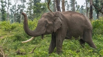
For large herbivores, these strips are not optional. Work from Thailand’s Tenasserim“Dawna Mountains shows that gaur herds, muntjac, sambar and wild pigs are more abundant in lowland than in montane forest, because grasses, bamboo, mineral licks and water sources converge in the lowlands. In the same landscape, elephants are pushed upslope into steeper montane forest by heavy hunting in accessible valleys, a reminder that human pressure can override the tendency to concentrate in low-lying resource-rich areas. In East Africa’s Serengeti, large herbivores like elephants and buffalo are disproportionately associated with riverine and woodland habitats compared with smaller species. Across continents and ecosystems, the pattern repeats: where terrain, water and forage line up, big herbivores concentrate.
Goa sits at the intersection of these forces. Conflict incidents, from crop damage by wild pigs and gaur to leopard or occasional elephant incursions “ have been rising. Recently, the state government announced plans to draft a human“wildlife conflict policy after studying models from Kerala and Karnataka. That is a welcome step. However, if the policy focuses only on compensation and rapid response, without asking where and why animals are being squeezed into conflict, it might treat the symptoms rather than the causes.
One striking gap is the absence of systematic records. Karnataka’s work on conflict hotspots rests on thousands of geo-referenced incidents, mapped against land use, elevation, water distribution and settlement patterns. Goa has no comparable, publicly accessible dataset. Many events are handled informally, leaving little trace beyond the memories of farmers or forest staff. Without robust data, it is easy to frame conflict as random “straying” by animals, rather than a spatially patterned response to how valley and riparian habitats are being reshaped.
A valley-focused lens would ask different questions. Where are Goa’s remaining continuous valley forests, from the foothills down to tidal reaches? How are they being nibbled away by encroachment, infrastructure and unregulated tourism? Where do these valleys intersect with blocks of cropland, orchards and expanding peri-urban areas? In many parts of coastal Goa, low-lying forest grades directly into mangroves, bunded fields and fishing settlements. These land“water edges are rich in biodiversity and livelihoods “ and they are also the most likely routes along which animals navigate increasingly human-dominated terrain.
Recognising valley forests as ecological bottlenecks does not mean freezing development. It means being honest about trade-offs and designing around them. A road or transmission line aligned along a ridge, with planned crossings, may fragment habitat less than one that slices through the only wooded valley between a hill massif and a coastal wetland. Restoring riparian vegetation along degraded stretches can stabilise banks and provide movement cover for wildlife, potentially reducing the need for animals to detour through crop fields. In Goa’s estuarine reaches, maintaining forested buffers where rivers meet mangroves and salt marshes can help keep both wildlife movement and human use more predictable.
For the new policy, three shifts would make a disproportionate difference. First, invest in proper conflict record keeping: geo-tagged, time-stamped, and standardised across divisions. Second, map these records against valley forests, riparian zones, mangroves and midland plateaus, rather than treating “forest” as a single blanket category. Third, name valley habitats explicitly in Goa’s conflict and land-use decisions, not as incidental green spaces between the Ghats and the sea, but as strategic layers where small changes can have outsized effects.
On World Environment Day, global warming and biodiversity loss can feel abstract until we look at the particular habitats that hold landscapes together. In Goa, valley forests are exactly such habitats, they are narrow throats through which movement, resources, and now conflict are being forced.