PANAJI
The southwest monsoon may have arrived in Goa, albeit four days after its scheduled date, but large parts of the State are witnessing one of the weakest starts to the rainy season in recent memory, with some regions receiving less than 100 mm of rainfall and the last three days passing with virtually no rain at all.
Meteorologist and former National Institute of Oceanography chief scientist M R Ramesh Kumar described the situation as highly unusual for a month that brings widespread and sustained rainfall across Goa.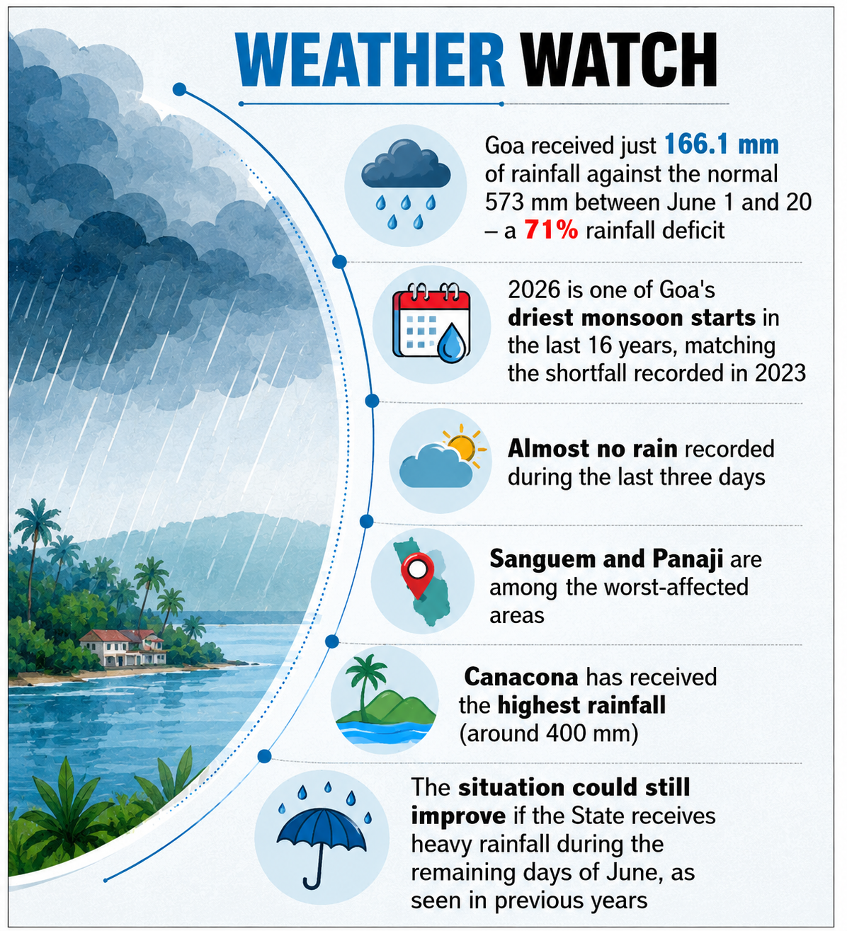 “This is a very bad story about the monsoon in Goa. At a time when the State is supposed to be receiving good rainfall, we have seen a hat-trick of dry days. The last three days have recorded almost zero rainfall across the State,” Kumar said, speaking to The Goan.
Data released by the India Meteorological Department (IMD) shows Goa received just 166.1 mm of rainfall between June 1 and June 20 against a normal of 573 mm, resulting in a massive 71 per cent deficit. The shortfall places 2026 among the driest monsoon openings recorded in Goa since 2010 and puts it on a par with 2023 for the highest rainfall deficiency during the first 20 days of June.
Uneven rainfall pattern
The rainfall distribution across the State has been highly uneven. According to Kumar, Sanguem has emerged as one of the worst-hit areas, with less than 100 mm of rainfall recorded so far this month. Even Panaji, which generally receives substantial monsoon showers during June, has witnessed exceptionally poor rainfall activity.
At the other end of the spectrum, Canacona has recorded the highest rainfall in the State at around 400 mm, followed by Mormugao, which received about 225 mm. Even these figures remain well below what is normally expected by this stage of the monsoon season.
The unusually dry conditions have left Goa feeling more like it is enduring an extended summer than experiencing its rainiest month. Daytime temperatures have remained elevated, humidity levels have stayed uncomfortably high, and overcast skies have often failed to translate into meaningful rainfall.
On Saturday, Goa recorded a temperature of 29.2 degrees Celsius, while the “feels like” temperature climbed to 35.5 degrees Celsius due to the high humidity.
Causes behind the weak monsoon
“The weak monsoon rainfall activity over Goa has been more pronounced in 2026,” Kumar said, attributing the situation to a combination of large-scale atmospheric and oceanic factors.
He pointed to weak cross-equatorial winds, a weaker-than-normal low-level jet stream, a weak tropical easterly jet stream, developing El Niño conditions over the eastern equatorial Pacific Ocean, and a neutral Indian Ocean Dipole as key reasons behind the sluggish monsoon performance.
IMD scientist Nahush Kulkarni, however, stated that Goa usually receives rainfall for about 20 days in June, while around 10 days are generally dry. “It is too premature to describe this as one of the driest monsoons. However, the monsoon is definitely weak at present,” he said.
Hope for recovery
Historical data suggests that June deficits can narrow dramatically if intense rainfall arrives during the final days of the month. In 2023, Goa had recorded an almost identical 71 per cent rainfall deficit up to June 20 after receiving 165 mm of rain. Heavy showers during the last 10 days of June subsequently reduced the monthly deficit to 30 per cent.
A similar recovery was witnessed in 2022, when a 47 per cent deficit as of June 20 narrowed to just 9 per cent by month-end. In 2010, too, the deficit improved from 32 per cent to 10 per cent following heavy rainfall during the final week of June.