PANAJI
A high-level government appointed Landslide Committee in its report submitted in November, last year, has proposed a minimum three-year scientific study covering the entire State, involving expert agencies and guidance from the National Disaster Management Authority (NDMA).
The study poposed focus on detailed mapping of vulnerable zones, area-specific precautionary guidelines, long-term monitoring mechanisms, development of future risk frameworks in line with NDMA norms, short-term restoration and mitigation measures, etc.
Landslide vulnerable areas
District Disaster Management Authorities have been asked to begin stabilisation works at least one month before monsoon in identified vulnerable areas including Baina, Sada, Rhumnawada, Verna, Loutolim, Cortalim, Betim, Malpe, Vimoda and areas behind Rayesh Chambers in Fatorda.
No relaxation in NDZs
The report states that no administrative exemptions should be granted within No Development Zones, warning that construction activity in these regions accelerates slope destabilisation and habitat degradation. Planning authorities have been directed to make geological and geotechnical studies compulsory before approving projects in landslide-prone areas.
The committee has proposed banning additional FAR and high-rise permissions in areas involving excavation deeper than four metres, warning that basement and deep foundation work could destabilise otherwise stable slopes.
Long-term engineering
solutions proposed
1) Reinforced Earth Walls for major slopes: For slopes exceeding 15 metres, the report recommends construction of Reinforced Earth (RE) walls, particularly in Mormugao, Fatorda and NH-66 corridors. These structures would combine compacted fill with reinforcement systems while integrating drainage measures.
2) Soil nailing and geotextile reinforcement: For medium-height cut slopes such as Cortalim, Betim and Loutolim, the committee recommends soil nailing with geo-fabrics and vegetative cover to prevent erosion.
3) Bioengineering and revegetation: Eco-restoration measures include planting Vetiver grass, Giant Reed (Arundo donax), Bamboo. The approach has been recommended for Vimoda, Malpe and NDZ buffer areas.
Taluka-level hazard
mapping recommended
The report proposes preparation of Taluka-wise slope zonation maps. Microzonation maps categorising areas as very high, high, moderate and low risk and Integration with cadastral maps to regulate future construction
Immediate action sought
at vulnerable locations
The committee has asked North and South Goa Collectors to immediately initiate precautionary measures at identified hotspots. Urgent directions include:
Fatorda: Safety audit of buildings and slopes behind Rayesh Chambers due to structural concerns.
Mormugao: Immediate evacuation and rehabilitation in pending cases.
National Highways: PWD directed to stabilise steep highway slopes using retaining walls and vegetation.
Malpe, Pernem: Drainage redesign recommended to avoid embankment wall collapse.
Betim: Residents living downslope near the Gurudwara identified as highly vulnerable and recommended for emergency allotments, alerts and long-term restoration planning.
The report further recommends declaring extreme-risk areas as No Development Zones and relocating vulnerable populations where necessary.
Other short-term
actions
Gabion toe walls and coir log installation; upgrading cross-drainage systems; slope monitoring through pegs and inclinometers; pre-monsoon inspections; vegetation restoration drives; temporary fencing and community alerts and need for national landslide susceptibility mapping.
Committee recommendations
Prohibiting construction on slopes steeper than 1:4 without exceptions
Mandatory geotechnical certification for all approvals
Creation of 100-metre risk buffers around landslide-prone sites
Unified approval systems integrating GSI, NDMA and TCP guidelines
Appointment of dedicated geological experts within TCP or empanelled agencies
Integration of NDMA landslide zonation datasets into building approval systems
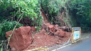
Landslide-prone locations identified (2025)
Satre, Karanjol and Zarme (Valpoi region)
Behind Rayesh Chambers, Fatorda
Verna Road after Cipla Circle
Loutolim Road
Near Baina Beach, Mormugao
Rhumnawada, Mormugao
Sada (Desterro), Mormugao
Cortalim underbridge zone
Malpe, Pernem
Vimoda, Pernem
Near Gurudwara, Betim
Conclusion
The committee warned that climate change, increasing cyclonic activity and rapid urbanisation could sharply intensify landslide hazards in Goa if corrective action is delayed.
It concluded that integrating engineering measures, bioengineering solutions and stricter planning controls backed by NDMA frameworks and scientific monitoring is essential to prevent future ecological and economic losses and build long-term resilience.