


the goan I network
MARGAO
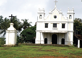
Will the South Goa Planning and Development Authority explain to Madgavkars why the Monte Hill Chapel area -- the last vestige of green cover in the heart of the commercial capital “ has not been shown in green colour in the land-use map?
The PDA officials may claim the land-use map only takes into account the structures existing on the ground and the land zones will be painted in their respective colours at the time of finalizing the city’s Outline Development Plan.
Many an eyebrow, however, has been raised over the failure to show the Monte Hill Chapel area in green colour as it comes against the backdrop of last year’s incident wherein a builder cleared the vegetation and the tree cover from the property on the land having slope.
The builder, it may be recalled, had last year cleared his property of the vegetation and trees and secured the land with a compound wall. While the TCP Minister Vijai Sardesai, after an inspection of the land in question, had promised to direct the land owner to grow trees and creepers, the ground reality has remained unchanged.
This incident had indeed raised fears in the minds of heritage lovers and citizens alike that the lush green cover on the Monte Hill playing host to the heritage chapel and the TB sanatorium may just disappear if the remaining owners of land along the slopes follow suit and clear the green cover from their properties.
When The Goan questioned Ashok D’Costa, the proprietor of Turbo Sketch, the agency engaged to put in place the land-use map, to shed light on the question as to why the Monte Hill chapel area has not been shown green on the map, he merely said the map only reflects the structures located on the ground. “Colours of different zones will be shown on the map at the time of preparing the ODP,” Ashok said.
SGPDA Member Secretary Ashok Kumar also echoed similar sentiments, saying that failure to paint a particular zone will not cause any harm at the stage of finalizing the land-use map as these are issues to be dealt with at the stage of finalization of ODP. “There’s nothing to worry if any zone is not shown properly. All these aspects will be taken care at the time of finalisation of ODP. As far as land-use map is concerned, it only shows the structures located on the ground,” Ashok Kumar said.
He, however, had no explanation why only Monte Hill Chapel area has been left out, while agricultural fields and open spaces are all painted green on the land-use map.
Sources in the know said there’s been repeated attempts by the owners of land on the Monte Hill Chapel area for conversion of the orchard zone to settlement, only to be turned down by the PDA. Last time around the PDA panel had opposed any conversion of the orchard zone to settlement, recommending to the PDA to retain the last vestige of the green cover around the Monte Hill Chapel area.


